

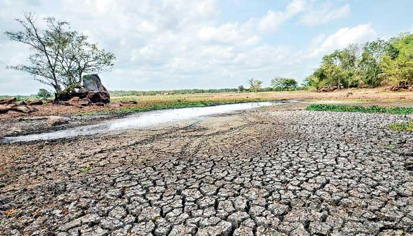
JAFFNA, Sri Lanka — Northern Sri Lanka should brace for a long spell of heat, growing strain on its water, and sharp swings from drought to downpour as El Niño gathers strength in the Pacific, a University of Jaffna climate scholar has warned.
Prof. Nagamuthu Pratheeparajah, a professor of geography and dean of the university’s Faculty of Arts, said people should start conserving water now and managing their wells, tanks, and reservoirs with more care, especially in districts that already run short every dry season.
He was speaking at an awareness programme run by the Women’s Right to Life Association at the Vadamaradchi East Divisional Secretariat. High temperatures and dry weather could hold into October, he said, naming Mannar, Kilinochchi, and Mullaitivu as the districts most exposed to water scarcity.
The warning lands at a moment when meteorological agencies at home and abroad agree on one thing: El Niño is here and building. What that means for Sri Lanka, though, is not simply months of unbroken drought.
The historical record points both ways. In an El Niño year, parts of the North and East can go without rain for long stretches and then take more than their share. The region may be looking at two problems back to back — water stress in the dry months, then heavy rain, flooding, and crop damage once the second intermonsoon and the northeast monsoon set in.
The United States National Oceanic and Atmospheric Administration moved the Pacific to an El Niño Advisory in June, raising it from a watch after sea-surface temperatures crossed the threshold. Its Climate Prediction Center now puts the odds of El Niño lasting into early 2027 at about 97 percent, and gives a roughly 63 percent chance the event turns “very strong” between November and January — strong enough to rank among the biggest since consistent records began in 1950.

Sri Lanka’s Department of Meteorology said much the same in an outlook dated July 2. Warmer-than-average water across the central and eastern equatorial Pacific, it reported, had come with shifts in atmospheric circulation that fit an El Niño pattern, and the event looked set to strengthen into the Northern Hemisphere winter of 2026-27.
The World Meteorological Organization puts the chance that El Niño stays the dominant Pacific state through at least November at near or above 90 percent. Its latest monthly Global Seasonal Climate Update spoke of a fast build toward a strong event over July to September, while warning that no one can yet pin down how high it will peak, or when.
What Is El Niño?
El Niño is not a storm, a cyclone or a heat wave. It is the warm phase of a recurring climate pattern called the El Niño–Southern Oscillation, or ENSO.
When an El Niño takes hold, the surface waters of the central and eastern tropical Pacific turn unusually warm, and the winds and pressure patterns above them shift. That reorders the way moisture and heat move through the atmosphere, and it can bend rainfall, temperature and storm behaviour thousands of miles away.
An El Niño does not hand every place the same weather, and it does not lock in drought or flooding anywhere. What it does is change the odds. Local monsoons, Indian Ocean temperatures, wind circulation and passing weather systems still do most of the work.
That matters for Sri Lanka. Rain here is ruled by the southwest monsoon, the northeast monsoon and two intermonsoon spells, and El Niño touches each one differently.
What the Official Forecast Says About July to September
Look at how past El Niño years actually played out, and there is no clean, across-the-board drop in rain over the North.
In July, the department found, rainfall in earlier El Niño events tended to sit near or below normal over most of the country, though the Western, Southern and North Western Provinces came out wetter, along with parts of Sabaragamuwa and the Ampara and Matale districts.
August flips the picture. Parts of Kilinochchi, Mannar, Vavuniya and Mullaitivu ran above normal in past El Niño years, and so did stretches of Anuradhapura, Puttalam, Matale, Ampara, Monaragala and Hambantota. Much of the rest of the country stayed near normal or a little under.
September usually landed close to the long-run average nationwide, a touch wetter in parts of Polonnaruwa and Monaragala, a touch drier in Puttalam.
These are tendencies from earlier years, not a district-by-district forecast for 2026. A district can post a near-average total for the season and still sit through long dry weeks, cop a few violent downpours, or watch one village drench while the next stays parched.
So the worry about heat and water stress is well founded, all the more because July through September is already a dry patch across much of the North and East. But the record does not say El Niño will simply bake the whole region for three straight months.
Why the North Is Vulnerable Even Without a Rainfall Collapse
The North leans hard on shallow groundwater, house wells, small tanks and whatever the season brings. When the rain thins out, drinking water, livestock, home gardens and cultivation feel it fast — most of all where the groundwater is already salty or pumped too hard.
Heat makes it worse. It pulls water off reservoirs and soil faster and pushes up demand in homes and fields at once, so farmers reach for more irrigation just as the wells and tanks refill more slowly.
The strain reaches past farming. A long hot spell raises the danger of dehydration, heat exhaustion and heatstroke, and it falls heaviest on the old, the young, outdoor workers and people already unwell. Schools, building sites and farms may have to shift their hours and make sure there is drinking water on hand.
El Niño can also nudge up global temperatures, because the Pacific gives off extra heat into the air. The WMO has said the building event raises the odds of heat waves on land and at sea, though no single hot spell can be laid on El Niño alone. Human-caused climate change has lifted the baseline that events like this one now sit on top of.
The East Could Face a Different Risk Later in the Year
October and November bring the second intermonsoon, when thunderstorms, low-pressure systems and cyclonic weather over and around the Bay of Bengal can dump heavy rain. The northeast monsoon that follows delivers the bulk of the year’s rain to the North and East.
And El Niño does not always choke off that rain. Sometimes it feeds it. In a study that others still build on, the climate scientists Lareef Zubair and Chester Ropelewski showed that the link between ENSO and India’s southwest monsoon has weakened over the decades, but the link between ENSO and the northeast monsoon over Sri Lanka and southern India, from October to December, has not — if anything the circulation firms up in a way that adds to the rain. A 2025 paper in the journal Climate Dynamics went further, finding that Sri Lanka’s northeast-monsoon rain answers the two phases of ENSO unevenly, with a much stronger and generally wetter response under El Niño than under La Niña.
Read together, they carry a warning: a dry run earlier in the year may not ease off gently. It may break in downpours.
For people in Jaffna, Kilinochchi, Mullaitivu, Mannar, Trincomalee, Batticaloa and Ampara, that means getting ready for both ends of it. Officials may have to guard drinking water now while they clear drains, mend irrigation works and get low-lying villages ready for floods months down the line.
Rain after a long drought does not always fix a shortage, either. A hard downpour can run straight off to the sea, swamp the drains, and foul open wells with floodwater, sewage or salt, while baked, packed soil turns much of the rest away.
The Indian Ocean Also Matters
El Niño will not have the last word on Sri Lanka’s weather. What happens in the Indian Ocean, and above all the Indian Ocean Dipole, can lift, blunt or reroute the Pacific’s pull. Through the October-to-December season the dipole often tracks the North and East’s rain more closely than the Pacific’s own Niño indices do.
The Department of Meteorology reported the dipole neutral in mid-June, with models hinting at a positive phase later in the year, most likely around August or September — though it cautioned that the forecasts scatter widely on both timing and strength.
A positive Indian Ocean Dipole usually means warmer-than-normal water in the western Indian Ocean and cooler water off Indonesia. How it plays with El Niño shapes rain across the wider region, but the outcome for Sri Lanka comes down to where several atmospheric systems sit and how hard they push.
That is why forecasters resist the image of El Niño “entering” the Indian Ocean. It works through winds, ocean temperatures, circulation and moisture, not as a mass of heat sailing toward Sri Lanka in one piece.
El Niño influences Sri Lanka not because heat physically travels across the ocean at a fixed rate, but because unusually warm waters in the tropical Pacific alter atmospheric circulation, wind patterns and moisture transport across much of the globe. Those large-scale changes can affect rainfall and temperatures in distant regions, including Sri Lanka, though local conditions in the Indian Ocean also play an important role.
Nor can anyone say for certain that low-pressure systems will hold off until after October. They are more common and usually more damaging for Sri Lanka during the intermonsoon and northeast monsoon months. But they can turn up at other times.
What Households and Authorities Can Do
Professor Pratheeparajah urged households not to waste water and to protect what they have — fixing leaks, going easy on treated water for non-essentials, keeping stored water covered, and keeping rubbish, wastewater and farm chemicals out of wells and tanks.
Local authorities can watch groundwater levels and salinity, flag the villages likely to run dry, line up emergency water deliveries, and get word to farmers before the crops are lost.
Health officials, for their part, can push heat warnings harder when temperatures spike, above all for outdoor workers and schoolchildren. Agriculture officers may need to steer farmers on planting dates, hardier crops, and irrigation as the season’s forecasts firm up.
Take the department’s outlook as an early warning, not a verdict. El Niño shifts the odds. It does not write the weather for any one village or district.
For the North and East, then, the smart move is not to dig in against drought alone or floods alone. It is to be ready for both, in that order.