India and Sri Lanka are separated by a sliver of sea. The cost of leaving it uncrossed grows by the year.
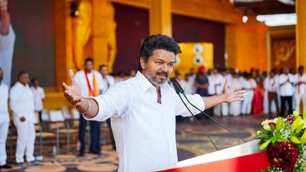
COLOMBO — On the morning of May 2, the Indian High Commissioner to Sri Lanka stood before an audience of businesspeople, policymakers, and diplomats at the Grand Ballroom of a Colombo hotel and said something that diplomats rarely say in public: that his host country was making a historic mistake, and that it needed to stop.
Santosh Jha, India's top envoy in Colombo, did not use those words exactly. He is a career diplomat, trained in the careful grammar of statecraft. But the substance of what he delivered at the Global Innovation and Leadership Summit — organised by Z Media and WION — was unmistakably direct. He called the absence of a land link between India and Sri Lanka "an anomaly." He said the engineering was understood, the economics were compelling, and the time for wavering was "over." He drew the image of two neighbouring rooms connected only by a long corridor outside, when a door could be built right through the wall between them.
"We need to open that door," Jha told his audience.
Weeks earlier, during President Anura Kumara Dissanayake’s December 2024 visit to New Delhi, Sri Lanka had quietly declined to advance the land bridge proposal. The project was removed from the formal agenda. When Prime Minister Narendra Modi visited Colombo in April 2025 and referred to land connectivity during bilateral talks, it was not on Sri Lanka’s agenda.
Jha’s speech was, in this context, a public argument directed not at an undecided audience but at a government that had already said no.
The Arithmetic of Absurdity
The closest points between India and Sri Lanka — the tip of Dhanushkodi in Tamil Nadu and the port of Talaimannar in Sri Lanka's Mannar District — are separated by approximately 30 kilometres of shallow water, in places no deeper than ten metres. By contrast, the sea route between Chennai and Colombo, the two countries' commercial capitals, spans roughly 740 kilometres. Ships must travel nearly thirty times the distance because no shorter path exists.
For citizens wishing to travel between India and Sri Lanka without flying, options remain extremely limited. A passenger ferry service exists between Nagapattinam and Kankesanthurai, but it operates on a relatively modest scale and currently depends on significant Indian government financial support to remain affordable. The roughly 110-kilometre crossing takes about three to four hours.
Yet despite the two countries lying just a few kilometres apart, there is still no direct road or railway connection. Nor is there an operational electricity grid linking the two countries, despite years of discussions over a submarine power cable. There is also no petroleum pipeline, even after Sri Lanka’s recent economic crisis exposed the country’s vulnerability to fuel shortages caused by foreign exchange constraints.
There was, once, a connection. The Indo-Ceylon Boat Mail, a colonial-era rail and ferry service, linked Madras to Colombo through Rameswaram and Talaimannar. The 1964 cyclone destroyed the Dhanushkodi railway line and left the town largely uninhabitable, forcing major changes to the route. But the Boat Mail service itself continued through Rameswaram until 1983, when it was suspended amid the worsening ethnic conflict in Sri Lanka. Nothing serious has been built since.
What the Studies Say
A 2023 analysis by Sri Lankan economists concluded that a fixed land link — bridge, tunnel, or a combination of both — would reduce transport costs in India–Sri Lanka bilateral trade by approximately 50 percent. Thirteen of the top fifteen products India currently exports to Sri Lanka, including sugar, pharmaceuticals, cotton, vegetables, and plastics, are suited to land transport, meaning they could immediately benefit from cheaper, faster, and more reliable logistics.
A fixed link would also give Sri Lanka access to a market of 1.4 billion people at drastically lower cost than today. It would create thousands of construction and operational jobs. It would allow the Northern Province to become a transit zone and growth corridor rather than a periphery.
The Pathfinder Foundation, a Colombo-based think tank, has outlined what it calls an “Economic Land Corridor”: not merely a bridge, but a spine for industrial zones, logistics parks, cold chains, and tourism clusters running along the Mannar–Trincomalee–Colombo axis. A research paper by Gayasha Samarakoon and Muttukrishna Sarvananthan, published by Routledge, describes the potential as a structural game-changer for both economies, estimating that a well-designed land corridor could transform the North’s share of national GDP within a decade.
“The engineering is well understood,” Jha told his audience in Colombo. “The economics are compelling. The benefits, wherever such bridges have been built, are unmistakable.”
The Precedents Are Overwhelming
When Denmark and Sweden opened the Øresund Fixed Link in July 2000 — a combined tunnel, artificial island, and cable-stayed bridge spanning the strait between Copenhagen and Malmö — the sceptics predicted disruption and warned of sovereignty erosion.
What followed was neither. The number of daily commuters crossing the strait grew from 3,291 in 2000 to 18,000 in 2010. Academic research found that residents of Malmö gained access to Copenhagen’s larger labour market, with total wage effects for Malmö residents rising by nearly 15 percent relative to pre-bridge levels eight years after opening. By 2024, more than 7.6 million vehicles were crossing the bridge annually. The region created around the link — 4.2 million people straddling an international border — became one of northern Europe’s most dynamic economic zones.
The Øresund project’s environmental record is equally instructive. The artificial island of Peberholm, created from dredged seabed material, was left entirely unplanted. Within a few years, more than 500 plant species and 30 kinds of nesting birds had colonised it unaided. Peberholm has been a Natura 2000 protected site since 2000 and is now closed to the public to preserve its wild state. An island built for infrastructure became, without human intervention, one of the most biodiverse sites in the Øresund region.
Both nations retained their passports, their legal systems, their tax regimes, their languages, and their sovereignty. The bridge did not make Sweden Danish or Denmark Swedish. It made both richer.
The Channel Tunnel, which opened in 1994 beneath the English Channel, tells a similar story at a larger scale. By 2024, it was carrying nearly 19 million passengers, 2.19 million cars, and 1.2 million trucks annually between France and the United Kingdom. It carries roughly a quarter of all EU–UK export value. And crucially, it has evolved beyond a transport corridor: the same tunnel infrastructure now hosts ElecLink, a 1-gigawatt electricity interconnector between the French and British power grids.
The Hong Kong–Zhuhai–Macau Bridge, which opened in 2018 as the world’s longest sea crossing at 55 kilometres, cut travel time between Zhuhai and Hong Kong International Airport from roughly four hours to 45 minutes. It placed cities across the Pearl River Delta within a three-hour commute of Hong Kong, transforming what had been a maritime barrier into a seamless economic hinterland.
None of these projects were straightforward. All faced cost overruns, political opposition, environmental concerns, and years of delay. All were built anyway. All changed the economic geography of their regions in ways their critics had said were impossible or dangerous.
The Energy Argument
Beyond the land bridge, Jha's speech pointed to a more urgent and much-needed dimension of connectivity: energy.
Sri Lanka's 2022 economic crisis, which caused queues stretching for miles at petrol stations, hospitals running on generators, and a sitting president fleeing by ship in the night, was in its most immediate form an energy crisis. The country ran out of foreign exchange to pay for imported fuel. The structural vulnerability that made this possible has not been resolved.
India has been studying an electricity interconnection with Sri Lanka since at least 1970. The current proposal involves a High Voltage Direct Current (HVDC) link running 285 kilometres from Madurai in Tamil Nadu to Anuradhapura in Sri Lanka's North Central Province, including 50 kilometres of submarine cabling through the Palk Strait. The initial phase, backed by the World Bank and targeted for completion by 2030, would transmit 500 megawatts of electricity in either direction, upgradeable to 1,000 megawatts.
Sri Lanka's own power planning documents, including the Ceylon Electricity Board's 2025–2044 generation plan, explicitly include the Indian interconnection in its base-case scenario — and for a reason that is not widely understood in public debate. As Sri Lanka adds solar and wind generation to meet its target of 70 percent renewable electricity by 2030, it faces an increasingly urgent problem: what to do with surplus power on sunny and windy days, and where to find backup on cloudy, windless ones. The CEB's planning documents warn that large-scale renewable curtailments — power generated but wasted because there is nowhere to send it — are expected to begin as early as 2026.
The answer, in power systems around the world, is interconnection. A grid link with India would allow Sri Lanka to export surplus renewable energy when it has too much, and import affordable power when it has too little. A joint feasibility analysis by Sri Lanka's Ministry of Energy and India's Power Grid Corporation found that in low-wind, peak-demand conditions Sri Lanka would import approximately 500 megawatts from India — but in high-wind, off-peak conditions, approximately 500 megawatts could flow in the opposite direction, from Sri Lanka to India.
The South Asian precedents are instructive. For Bhutan, hydropower export revenues to India account for over 40 percent of national government revenue, according to the Asian Development Bank — making it the single largest source of state income. Nepal, after years of energy shortfall, began its first electricity exports to Bangladesh in June 2025, transiting 40 megawatts through India's grid in a landmark trilateral arrangement. Academic modelling — including a USAID-commissioned study by the Integrated Research and Action for Development — projects that Nepal's full participation in cross-border electricity trade could increase its GDP by up to 39 percent by 2045 under accelerated trade scenarios. These are sovereign nations with their own foreign policies. None of them has been absorbed into India. All of them are more energy-secure, and more economically resilient, than they were before interconnection.
The Fears, Examined
Sri Lanka's caution about deeper connectivity with India is not irrational. It is rooted in history, in the asymmetry of power between a nation of 22 million and a neighbour of 1.4 billion, and in a political culture that has spent decades calibrating the distance between partnership and subordination.
The most persistent fear is sovereignty: that a physical link would give India leverage over Sri Lanka's domestic politics, that Indian capital and goods would overwhelm local industries, that demographic pressures would follow the roads. President Anura Kumara Dissanayake, who took office in late 2024, stated publicly in 2025 that Sri Lanka was "not yet ready" for a land connection.
These concerns deserve to be taken seriously. They should not, however, be allowed to go unexamined.
On sovereignty: Sri Lanka is already deeply embedded in India's economic orbit. India is already Sri Lanka's largest trading partner, its largest source of tourists, and its largest foreign direct investor, with cumulative investments exceeding $2.2 billion. The question is not whether Sri Lanka is in India's sphere of economic influence. It already is. The question is whether Sri Lanka manages that reality from a position of structural strength — as a connected hub, an energy-exporting node, a transit economy — or from a position of structural weakness, as an isolated island that pays a premium for everything it imports and has no fallback when supply chains break.
On economic domination: The experience of Nepal and Bhutan demonstrates that smaller South Asian neighbours of India can negotiate cross-border arrangements that serve their interests without becoming client states. The critical variable is not whether connectivity is pursued, but how it is structured — what pricing formulas govern energy trade, what safeguard clauses protect sensitive industries, what dispute mechanisms exist, and what Sri Lanka extracts in return for access to its territory and infrastructure.
On environment: the Palk Strait and the Gulf of Mannar are among the most ecologically rich marine environments in South Asia, with coral reefs, seagrass beds, dugong habitats, and high biodiversity recognised by UNESCO. This is a legitimate concern, and it would be irresponsible to minimise it. But it is also a design problem, not a veto. The Øresund project allocated approximately 14 percent of its total cost to environmental mitigation, and the artificial island of Peberholm has since become a managed wildlife habitat. Rigorous environmental impact assessments, careful route selection, a hybrid bridge-and-tunnel design in the most sensitive sections, and no-go ecological zones are not incompatible with the project — they are conditions for it.
The Northern Province: The Stakeholder No One Mentions
Mannar, the island district in Sri Lanka's Northern Province through which any Palk Strait fixed link would pass, is one of the most economically devastated areas on the island. It was heavily militarised during the civil war, its population displaced multiple times, its fishing communities restricted by military presence and by the conflict that used its waters as a transit zone for weapons, people, and desperate refugees. The land around Mannar has been the subject of military land occupation complaints. The communities there remain among the poorest in the country.
Before 1983, Tamil traders, students, pilgrims, and families moved between Jaffna and Tamil Nadu as a matter of ordinary life. Boat services, trade networks, and family ties connected the communities across the strait in ways that the war, the displacement, and decades of isolation have now severed across two generations. The post-war generation in the North has grown up without the Tamil Nadu connections their grandparents regarded as natural.
A land link through Mannar, if designed with genuine attention to the Northern Province's interests, could be the most transformative infrastructure project in the history of post-war Tamil Sri Lanka. It could convert Mannar from a periphery into a gateway. It could unlock religious and cultural tourism along circuits that connect Rameswaram, Mannar, Anuradhapura, and Jaffna in ways that serve Tamil and Sinhalese pilgrims alike.
What Sri Lanka Stands to Lose
Sri Lanka has spent the two decades since its civil war ended trying to position itself as a maritime and logistics hub — a Singapore of the Indian Ocean, a services and transshipment node that earns from geography rather than from raw materials. It is a reasonable ambition for an island at the junction of major Indian Ocean shipping lanes, with a well-educated workforce and a long tradition of openness to trade.
But the strategy has a structural problem: Sri Lanka is trying to be a hub without the connectivity that hubs require. Changi Airport's supremacy rests not just on its own excellence but on Singapore's integration into the ASEAN economy and its role as a connector between Southeast Asia and the rest of the world. Rotterdam's dominance in European freight rests on its connections to the Rhine corridor, the German industrial heartland, and the European rail network. A hub that is not connected to its hinterland is not a hub. It is a very good island.
Sri Lanka currently has no land connection to any of the world's major economies. It has no electricity grid connection to a larger system. It has no pipeline. It sits 30 kilometres from a country of 1.4 billion people and pays for everything it imports as if that distance were an ocean rather than a strait.
This is the cost of the anomaly.
The Door in the Wall
Jha's metaphor — two rooms connected by a corridor when there is a door that could be built in the shared wall — is, on reflection, slightly too modest. What he is describing is not just the convenience of a shorter path. It is the difference between two rooms that remain separate, organised around their own interiors, and two rooms that become something new because of what flows between them.
In the quarter-century since the Øresund Bridge opened, the cities of Copenhagen and Malmö have become, for most practical economic purposes, a single labour market, a single tourism destination, and an integrated innovation region — while remaining politically, legally, and culturally distinct nations. Denmark did not cease to be Denmark. Sweden did not become an extension of Denmark. Both became richer, more dynamic, and more resilient because of the 16 kilometres of water they chose to cross.
Sri Lanka and India have not crossed 30 kilometres in 61 years. The reasons are understandable. The historical baggage is real, the political sensitivities are genuine, and the engineering challenges are non-trivial. But the evidence from every comparable project in the world points to the same conclusion: the cost of not building is higher than the cost of building, and it compounds every year.
"The time for wavering is over," Santosh Jha said in Colombo.
Whether Sri Lanka agrees will be one of the most consequential decisions its political leadership makes in the decade ahead.